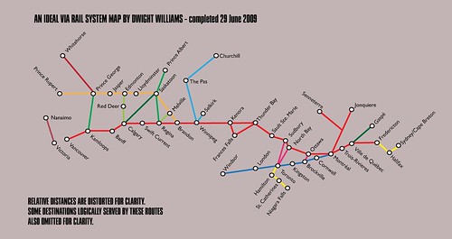
I had some ideas on what the route map for VIA Rail ought to look like ten years from now. Granted that in several respects - costing out the details surely being among them - it is indeed a fantasy. Nonetheless, the choices made sense to me as I drew them up.
So, for your amusement at the publicbroadcasting.ca blog...
Opinions, anyone?

2 comments:
It's pretty clear you don't live in the east. That said...
- Kamloops to PG doesn't make a while lot of sense, because the existing lines (Kamloops - Valemont - prince George) is almost a straight line. Check a map. Still, an upper Fraser Valley route might make sense if extended and connected to Dawson Creek
- what *does* make a lot of sense though are an Okanagan route, from Osoyoos to Kelowna to Penticton to Salmon Arm, and a Kootoney route, from Golden to Cranbrooke, all of which would link to a southern Crowsnest line
- Whitehorse makes sense only with an extension to Alaska, and would connect to the south via Dawson Creek, Grande Prairie and Edmonton, not Prince George, because it's shorter and faster and has population centers.
- Calgary - Saskatoon makes sense only if the line through PA is extended to the Pas (which is actually NE of PA).
- The Saskatoon to Winnipeg rail line connects with the southern line in Portage La Prairie, not Brandon. The actual routes connect in Winnipeg, as they should.
- You can't make the national east-west route run through Thunder Bay and the Soo -- it's much too long. The existing route runs through Sioux Lookout and Longlac (north of Lake Nipissing) thus avoiding the twists and turns through the deep valleys leading to Lake Superior. The southern route is very much a local/tourist route. Reinstating it along existing tracklines is a good idea. A spur to Ft. Francis / International Falls would be a good connection to the U.S. but should probably simply run straight north to Kenora
- if you *must* run two lines north from Toronto, at least split them where it makes sense, at Parry Sound.
- Toronto - Windsor is a good idea. But why drop the existing Toronto Sarnia route? Also, two lines north? No, one line, with a short spur from Parry Sound
- Ottawa to Kingston (following existing routes and population centres, and also taking a shorter route to Toronto) makes more sense than Ottawa to Brockville
- what would be really useful in Quebec is Shawinigan - Trois Riviers, and Quebec City to Riviere-a-Pierre
- It doesn't make sense to route through Fredericton - the existing Montreal - Levis (Quebec south shore) - Halifax line runs long the coast. Instead, what would be nice is a reinstatement of the cross-Maine route, which connected Fredericton and Moncton. A link to the port of Saint John is also desirable, as a spur.
- Nova Scotia desperately needs an Annapolis Valley line, ideally extending to Yarmouth
- Newfoundland needs rail connecting St. John's , Gander, Corner Brook and Port Aux-Basques
Here's my map. http://www.downes.ca/images/railmap.jpg
See some of my comments in partial reply on the original Flickr page holding this map.
I'm still working on a 2035 edition with ideas on the next phase, and hoping to get back to that and revising the 2010 edition to correct some of the obvious mistakes and gaps.
Anyone else with an interest, please speak up!
Post a Comment